Chad
Chad, officially known as the Republic of Chad,
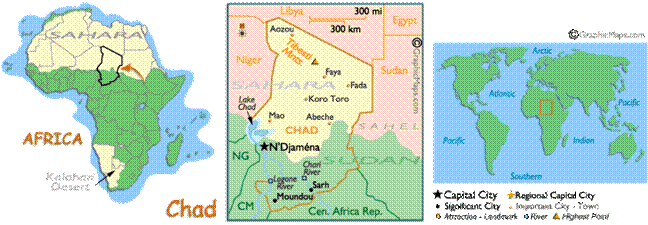
is a landlocked country in central Africa. It
is bordered by Libya, Sudan, the Central
African Republic, Cameroon,
Nigeria and Niger. Due to
its distance from the sea and its largely desert climate, the country is
sometimes referred to as the "Dead Heart of Africa". Chad is divided
into three major geographical regions: a desert zone in the north, an arid Sahelian
belt in the centre and a more fertile Sudanese savanna zone in the south. Lake
Chad, after which the country is named, is the largest wetland in Chad and the second largest in Africa.
Chad
is home to over 200 different ethnic and linguistic groups. Arabic and French
are the official languages. Islam and Christianity are the most widely
practiced religions.
Beginning in the 7th millennium
BC, human populations moved into the Chadian basin in great numbers. By the end
of the 1st millennium BC, a series of states and empires rose and fell in Chad's Sahelian
strip, each focused on controlling the trans-Saharan trade routes that passed
through the region. France
conquered the territory by 1920 and incorporated it as part of French Equatorial Africa. In 1960 Chad obtained
independence.
The country is one of the poorest
and most corrupt countries in the world; most Chadian live in poverty as subsistence
herders and farmers. Since 2003 crude oil has become the country's primary
source of export earnings, superseding the traditional cotton industry.