Ecuador
Ecuador, officially the Republic of Ecuador,
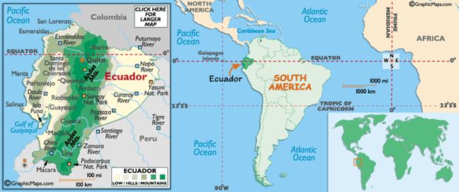
is a country in South America, bordered by Colombia
and Peru, and by the Pacific Ocean to the west. It is one of only two
countries in South America (with Chile)
that do not have a border with Brazil.
The country also includes the Galápagos Islands
in the Pacific, about 965 kilometers west of the mainland. Ecuador
straddles the equator, from which it takes its name.
Many
civilizations rose throughout Ecuador,
such as the Valdivia Culture and Machalilla Culture on the coast, the Quitus and
the Cañari. Ecuador
became part of the Inca Empire in 1463 and fell under Spanish control in 1530. Ecuador gained its independence from Spain in 1822 and joined Gran Colombia soon
after, then became a republic in 1830. Revolts and dictatorships
followed; it had 48 presidents during the first 131 years of the republic.
Conservatives ruled until the revolution of 1895 ushered in nearly a half
century of Radical Liberal rule, during which the church was disestablished and
freedom of worship, speech, and press was introduced. Although it was under
military rule in the 1970s, the country did not experience the violence and
repression characteristic of other Latin American military regimes.
Peru
invaded Ecuador
in 1941 and seized a large tract of Ecuadoran territory in the disputed Amazon
region. In 1981 and 1995 war broke out again. In May 1999, Ecuador and Peru signed a treaty ending the
nearly 60-year border dispute.