Guadeloupe
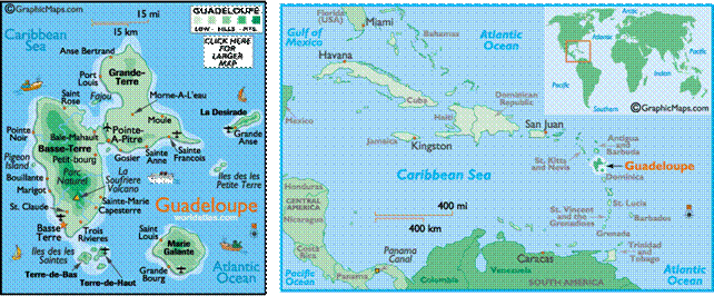
Guadeloupe is
an archipelago located in the Leeward Islands, in the Lesser
Antilles. It consists of two large islands, Guadeloupe
proper and Grand-Terre, together with five smaller dependencies. It is the
first overseas region of France,
consisting of a single overseas department.
Christopher
Columbus landed on Guadeloupe on November 4,
1493. Though originally called Karukéra (Island
of Beautiful Waters) by the Carib
Indians, Columbus
named the island after the famous sanctuary of Santa Maria de Guadalupe de
Estremadura. Lacking gold and silver, the island was not of great interest
to the Europeans until the17th century. For a brief period the Spanish had
tried to settle Guadeloupe but were stopped by
the ferocious Carib Indians. Then around 1635, the French began to colonize the
island. With the institutionalization of slavery in 1644, the trade of spices,
sugar, tobacco and rum prospered between France,
Africa and the Antilles.
Guadeloupe was officially annexed by the King
of France in 1674. As the island prospered, it became the scene of great
battles between the French and the British, who occupied it from 1759 to 1763.
That year it was restored to France
in exchange for all French rights to Canada. But the tug-of-war
continued on and off until 1815, when the Treaty of Paris designated Guadeloupe as French. In 1848, thanks to the efforts of
Victor Schoelcher, slavery was abolished. Guadeloupe
was represented for the first time in the French Parliament in 1871. It became
a French Départment on March 19, 1946.