Zimbabwe
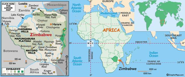
Zimbabwe, officially the Republic of Zimbabwe
and formerly Southern Rhodesia
and the Republic of Rhodesia,
is a landlocked country located in the southern part of Africa.
It is bordered by South Africa,
Botswana, Zambia and Mozambique. Zimbabwe has
three official languages: English, Shona (a Bantu language), and Ndebele.
There were several native kingdoms
existed before Zimbabwe became as a part of the British crown colony of
Rhodesia, then called Zambesia, in 1888. In 1898 Southern Rhodesia became the
official denotation for the region south of the Zambezi, which later became Zimbabwe. The
region to the north was later named Northern Rhodesia (now Zambia). Southern Rhodesia became a self-governing British colony
in October 1923, subsequent to a 1922 referendum. In 1953; in the face of
African opposition, Britain
consolidated the two colonies of Rhodesia
with Nyasaland (now Malawi)
in the ill-fated Federation of Rhodesia and Nyasaland which was dominated by Southern Rhodesia. Growing African nationalism and
general dissent, particularly in Nyasaland, admonished Britain to dissolve the Union
in 1963, forming three colonies. As colonial rule was ending throughout the
continent and as African-majority governments assumed control in neighboring Northern
Rhodesia and in Nyasaland, the white-minority Rhodesia
government made a Unilateral Declaration of Independence from the United Kingdom
on 11 November, 1965. The United
Kingdom deemed this an act of rebellion, but
did not re-establish control by force. The white-minority government declared
itself a republic in 1970. Southern Rhodesia dropped the designation ‘Southern’,
and claimed nation status as the Republic
of Rhodesia. British
granted the independence to Rhodesia
in 1980 and the name of Zimbabwe
was formally adopted.